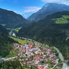
The commune Luče is situated in the north of Slovenia, in the eastern part of the Kamnik-Savinja Alps, and covers an area of 110 km². The centre of the municipality is located in the village Luče, which is situated on the river terrace above the confluence of the Savinja and Lučnica rivers at an altitude of 522 metres.
There are small settlements and remote farms around the village. The nearby peaks of the Savinja Alps are made up of Triassic limestone and Dolomites, while the lower peaks are made up of andesite. The latter is the result of the volcanic eruptions of Smrekovec 30 million years ago. The surface is very structured, which is due to a rich geological structure and strong tectonic movements.
The landscape is characterized by hills and mountains with intermediate valleys along the rivers Savinja, Lučnica and Lučka Bela with features of alpine, karst and pre-alpine silicate jump. Almost half of the municipal area is part of the Natura 2000 nature reserve.
General information
Height above sea level of Luče: 522 m
Highest point: 2,350 m (Ojstrica)
Resident population in the municipality: 1,521 (2019)
Hamlets
- Luče
- Krnica
- Podvolovljek
- Podveža
- Raduha
- Strmec
- Konjski Vrh
Mountain range
Kamnik-Savinja Alps
Main peaks
- Ojstrica (2,350 m)
- Velika Zelenica (2,114 m)
- Veliki Vrh (2,110 m)
- Raduha (2,062 m)
- Lučki Dedec (2,023 m)
- Deska (1,970 m)
- Dleskovec (1,965 m)
- Križevnik (1,909 m)
- Lastovec (1,841 m)
- Rogatec (1,557 m)
- Lepenatka (1,425 m)
Press release October 2nd, 2019
Slovenia has a new mountaineering village: Luče …


