


 im Natura-2000-Gebiet")
")

From leisurely to pure adrenalin - hikes to suit all tastes
The uncontaminated lands around Lungiarü are a true gem for nature lovers, hikers and mountaineers, and range from the adrenalin-packed to leisurely to relaxing: You will find numerous tours in this area, nestled in the breathtaking scenery of the Dolomites, a UNESCO World Heritage Site since 2009. In the area around the mountaineering village, far from the hustle and bustle of everyday life, everybody who loves the countryside is sure to be in his or her element. The following information on times and altitudes always refers to the actual tour itself, not the variants, and are to be read as a guide only.
For the demanding tours, maps are always recommended. The hikes and mountain tours are grouped according to starting points.
Loop routes
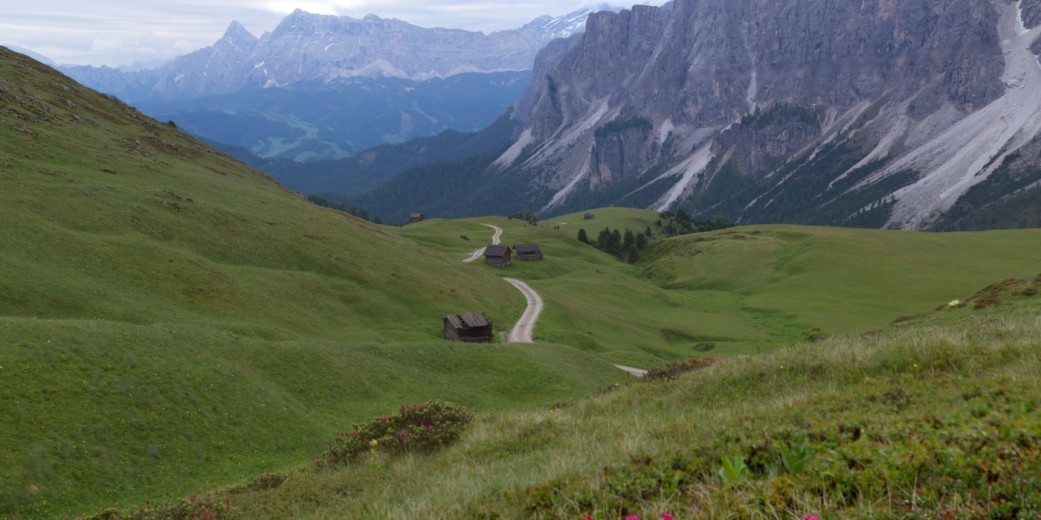
Roda dles Viles
The Roda dles Viles is a leisurely walk from the village centre to the distinctive Ladin Viles.
- Rundweg
- Altitude difference: 684 m
- Time: 4 h
Along the route you will discover the traditional farms of this area and their characteristic architecture of farm buildings, barn, oven and mill during a true and proper immersion into the centuries-old culture of mountain farming. On the dirt trails between the Viles we meet with “mother nature” at her finest and enjoy a magnificent panoramic view of the surrounding mountains. None of the trails are particularly steep, making this route well-suited for everyone.
Val di Morins / Mühlental
Given the many water mills located in this area, the valley along the Seresbach River is also known as the Mühlental (“Mill Valley”). The mills ran only in the autumn months, for the time it took to grind the grain.
- Loop route
- Altitude difference: 100 m
- Time: 45 min
Situated on the edge of the Puez-Geisler Nature Park and at the foot of the Pütia/ Peitlerkofel, the Mühlental Valley and the hamlets of Seres and Miscí are among the most interesting rural forms of settlement in the Gadertal Valley. This loop route begins at the small bridge on the Seresbach River near the first mill. The return stretch leads away from the river to the hamlet of Seres and the lime kiln.
Starting from the village centre
Lungiarü – Spizan – Lungiarü
This beautiful loop route leads over the eastern ridge of Lungiarü. From the village centre, the trail leads out of the valley along the main road to begin with.
- Highest point: Spizan 1,835 m
- Altitude difference: 440 m,
- Time: 4-5 h
Von Ties geht es rechts über eine Forststraße Richtung Chi Jus, von dort aus weiter nach Süden über Spizan (1.835 m). Die fantastische Aussicht auf das gesamte Campiller Tal sowie auf die Nachbargemeinden La Val/Wengen und Badia / Abtei genossen, gelangt man der Richtung Cëindles folgend bis nach Juvel. Von dort erfolgt die Rückkehr über die Rodelbahn bis nach Lungiarü.
Lungiarü – Göma
For this tour, take the bus to San Martin de Tor/ Lungiarü junction (journey time approx. 8 min). Route no. 9 is fairly hard-going, but you will be well-rewarded for your efforts with breathtaking views: firstly on the Ciastel de Tor, then further up near the neighbouring village Antermëia/ Untermoj and the Ju de Börz/ Würzjoch.
- Highest point: Göma 2,111 m
- Altitude difference: 980 m
- Time: 5-6 h
With the Pütia/ Peitlerkofel in our line of vision, we walk on to Göma, where we meet with the Peitlerkofel loop route. From here, the trail leads down beautiful mountain meadows to the forest road, which takes us in the direction of Ví, to Lungiarü. This forest road is also known as the “Open Air Museum,” and offers not only a leisurely hike, but also fascinating insights into the local cultural scene: Along the route, you will encounter numerous wood-crafted works of art, sculptures and façade designs by a local artist.
Alternatively, the return trail from Göma to the Ütia Vaciara hut (take route 4A to the Val di Morins/ Mühlental) also leads back to the village.
Starting from Pares
Munt d'Adagn
A tour that is thoroughly recommended for families with children!
From the Pares car park we take forest road no. 5 into the valley. After around 1 km we take the turn-off to the right and follow the forest road through the cool woodland until the view opens out onto the first alpine meadows.
- Highest point: Munt d’Adagn 2,293 m, Alternative: Piza de Medalges 2,454 m
- Altitude difference: 700 m
- time: 4 h
From here it is not far to the Ütia Ciampcios hut, which also serves refreshments. The next stop is the Medalges Alm and, if you have enough energy left, you can also make your way to the Piza de Medalges summit (2,454 m) with beautiful views of the Villnösstal Valley. The first stretch of the return route follows the same path until the tree line, where we take the slightly more level forest road no. 5A to the car park.
Val di Morins / Mühlental – Schlüterhütte mountain hut
This walking route begins at the Pares car park and leads up through the Val di Morins/ Mühlental Valley. Keeping constantly to the left on trail no. 4, take the fairly steep ascent to the tree line where the terrain levels out.
- Highest point: Schlüterhütte mountain hut 2,306 m
- Altitude difference: 800 m
- Time: 5 – 6 h
After crossing the magnificent mountain meadows and past rustic hay huts you will come to a saddle, from where a short descent on the Villnöss side leads to the Schlüter hut. The descent can follow the same route, but it is well worth taking the Dolomites Höhenweg High Mountain Trail up to the Juvac Scharte saddle with breathtaking views of the Puez peaks. Return to the set-off point via Medalges and forest trail no. 5.
Peitlerkofel loop route
Set off from the Pares car park and make your way upwards through the Val di Morins/ Mühlental. At the second crossroads, however, take the trail on the right, no. 4B, to Forcela de Pütia/ Peitlerscharte.
- Highest point: 2,357 m
- Altitude difference: 900 m
- Time: 5-6 h
From there, head downhill and follow trail no. 8A past the Munt de Fornella towards the Ütia Göma hut, where the climb up to the Göma-Scharte saddle begins. The terrain levels out somewhat here, and leads first to the Ütia Vaciara hut and then over the Pra de Pütia/ Peitlerwiesen meadows, which are in full bloom during the spring and summer months. At the crossroads, follow trail no. 4B down to the valley.
Starting from Cialdires
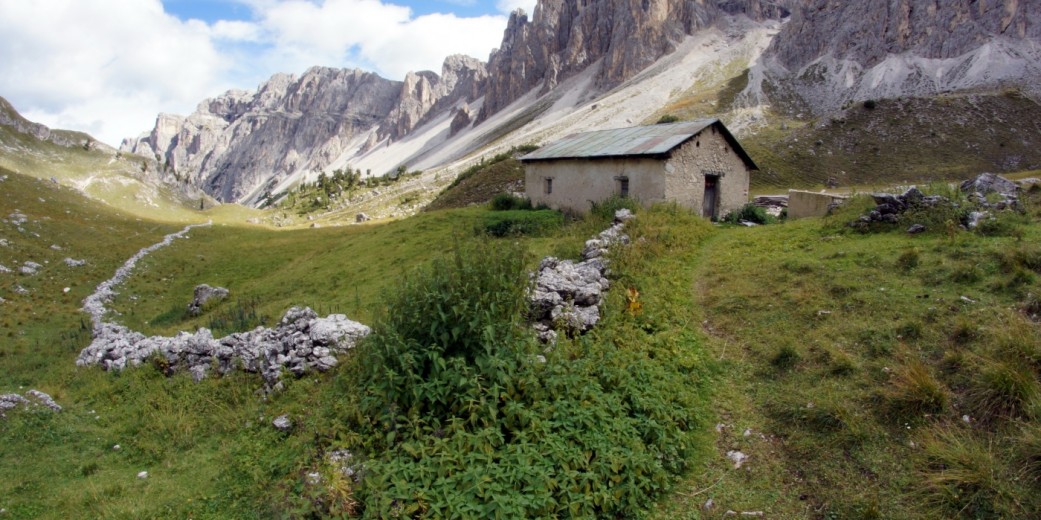
Antersasc
From the Cialdires car park follow trail no. 6 to a slightly wider forest road and fence. Go through a gate and you will come to a narrower path up to the Antersasc-Alm.
- Highest point: 2,085 m
- Altitude difference: 500 m
- Time: 2 h
The mystical Antersasc is an impressive destination for both its numerous hiking possibilities, – it is the starting point for a number summit tours (see mountain tours) – and also for its idyllic, romantic beauty. When surrounded by the magnificent rock faces in this alpine pasture of Antersasc, also known as the Zwischenkofelalm, you cannot help but feel the magic and power of nature in the all-but untouched countryside of this valley. Return along the same route.