


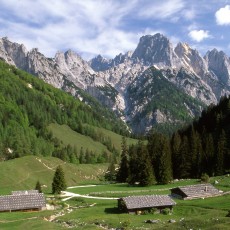

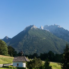
The village of Ramsau is situated at 630 m above sea level, while the highest peaks in direct vincinity reachs hights of more than 2,700 m.
More challenging trips are to be found in the “Berchtesgaden Alps”. The highest peaks of the area and thus the greates view points can be reached, but ask for a bit of endurance and technical abilities. The feather on the hat is the traverse of the entire Watzmann-massif from the Hocheck via the “Middle Peak” to the “South-Peak”.
Halsalm - Adlerweg
If you are a bit lucky, on this trip you can catch sight of one of the golden eagles, which are nesting in the rock faces of the Reiteralpe.
From the parking follow the paved road into the National Parc (Hirschbichlstraße). After about 15 minutes turn right onto a forest road, which then climbs steeply into the forest. After a first clearing the old building of the farm “Halsalm” is appearing and invites for an extended rest.
- Trail N°.: 63
- Length: 6 km
- Elevation gain: 450 m
- Total Duration: 3 ½ hours
- Difficulty: simple
- Starting point: Public parking at the Visitor’s Center of the National Park at Hintersee
The descent follows a different path down towards Hintersee. From the farm continue east on a small trail. Accompanied by great views of Ramsau and the Hintersee, the trail takes you directly to Hintersee. From there it is only a little stroll along the lake back to the staring point.
Project partners in close vincinity to the starting point
The "Toter Mann": a panoramic view point and an ancient salt pipeline
From the parking follow the trail/road N° 66/67 all the way to the restaurant Hirschkaser. From the Hirschkaser it is another 10 minute walk to the summit of “Toter Mann”, where you can enjoy the best panoramic view of the Berchtesgaden Alps and the National Park.
After a break at the small Betzold-Hut, it is time to continue to the guarded mountain hut Söldenköpfl.
- Trail N°: 66, 67, 68
- Total Distance: 12 km
- Elevation Gain: 500 m
- Total Duration: 4 hours
- Difficulty: simple
- Starting point: Public parking Schwarzecker Straße
From there you follow the path of the former salt pipeline to the restaurant Zipfhäusl and back to the starting point.
Project partners in close vincinity to the starting point
Round trip of the Schmuckenstein
The trip takes you to one of the highest alpine farms of the region, the Schmuckenlehen. From there you follow trail 75 to the Mordaualm (alpine meadows), while enjoying great views of the surrounding mountains.
The farm is guarded during the summer months, so that you can get a taste of cheese, mild and other homemade products.
- Trail N°: 75
- Length: 8.5 km
- Elevation gain: 250 m
- Total Duration: 3 hours
- Difficulty: simple
- Starting point: Public parking Hochschwarzeck
Project partners in close vincinity to the starting point
The Klausbach Valley
The trip follows an important ancient trade route: precious salt was transportet from Ramsau across the Hirschbichlpass to Weibach b. Lofer in Austria.
To get to the pass, you follow the hiking trail along the entire valley rising gently towards the west. After passing alpine meadows and mixed forests, the trails steepens.
- Trail N°: 2/481
- Length (one way): 7 km
- Elevation gain: 400 m
- Total Duration: 2 ¼ hours
- Difficulty: simple
- Starting point: Public parking Hirschbichlstraße
Surrounded by the steep rock faces of the Reiteralm (also known as the Dolomits of the Ramsau) you pass the alpine meadow of the Bindalm and finally reach the pass.
A recommded extension: continue to the alpine meadows of the Litzlalm (2.5 km, ¾ hours, 175 m elevation gain).
Depending on your fitness, the weather or your available time, you can easily shorten the trips in the Klausbach Valley by using the one and only shuttle service for hikers, climbers and mountaineers: the so called AlmErlebnisBus, stops along the road from the Hirschbichlpass to the lake Königssee.
The only public tansport that takes you into the National Park! It takes you from the Lake Hintersee through the Klausbach Valley to the Hirschbichl Pass and further to the minicipality of Weißbach bei Lofer – also a Mountaineering Village!
- Maria Alm – Saalfelden – Weißbach – Hirschbichl – Hintersee
timetable at almerlebnisbus.com …
Project partners in close vincinity to the starting point
The Wimbach-Gorge and Wimbach Valley
A hike through the Wimbach Valley is an unforgettable experience. First you hike through a wild and narrow gorge. Lateron the scale changes and you will find yourself ina large valley with braided river systems between Watzmann and Hochkalter.
- Trail N°.: 421
- Length: 8.5 km
- Elevation gain: 700 m
- Total Duration: 3 ½ hours
- Difficulty: simple
- Starting point: Public parking Wimbachbrücke
Project partners in close vincinity to the starting point
Hiking to historic and natural sights:
Along easy trails you can reach a couple of sites, that have a significant importance in the history of the village of Ramsau.